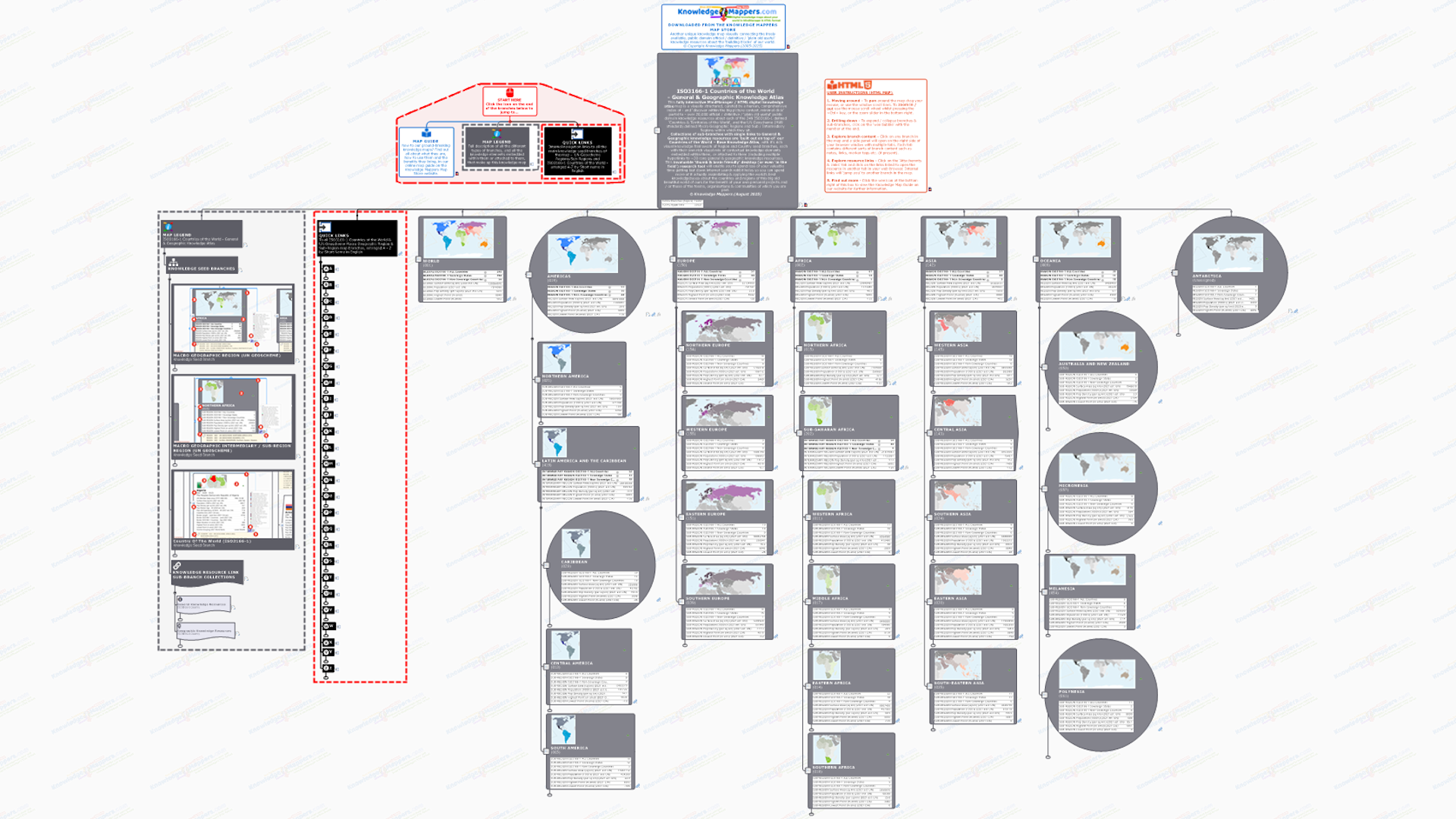
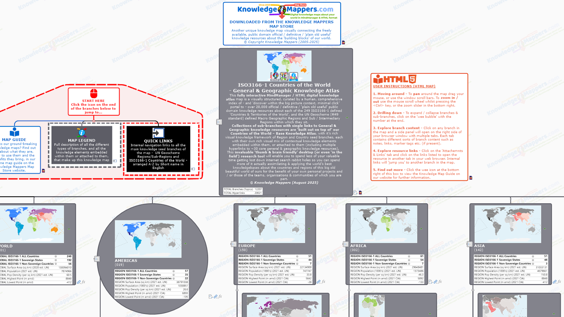
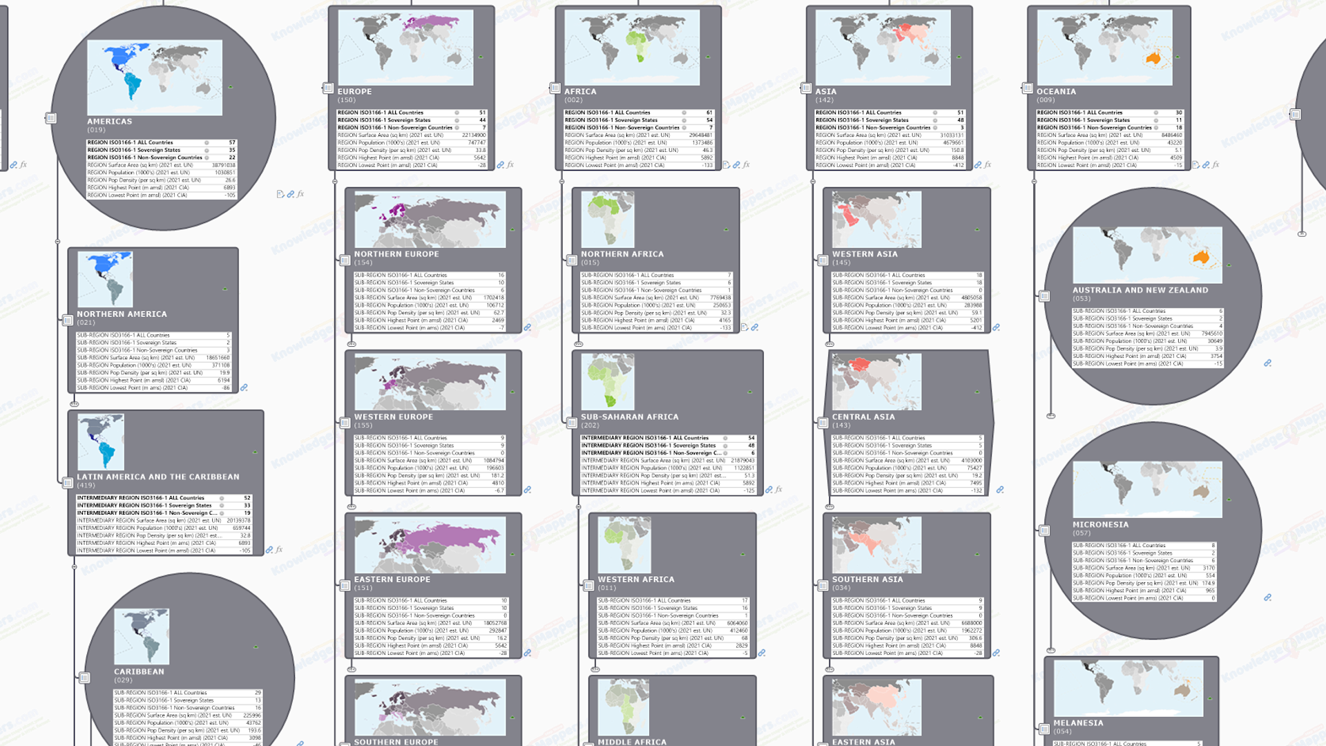
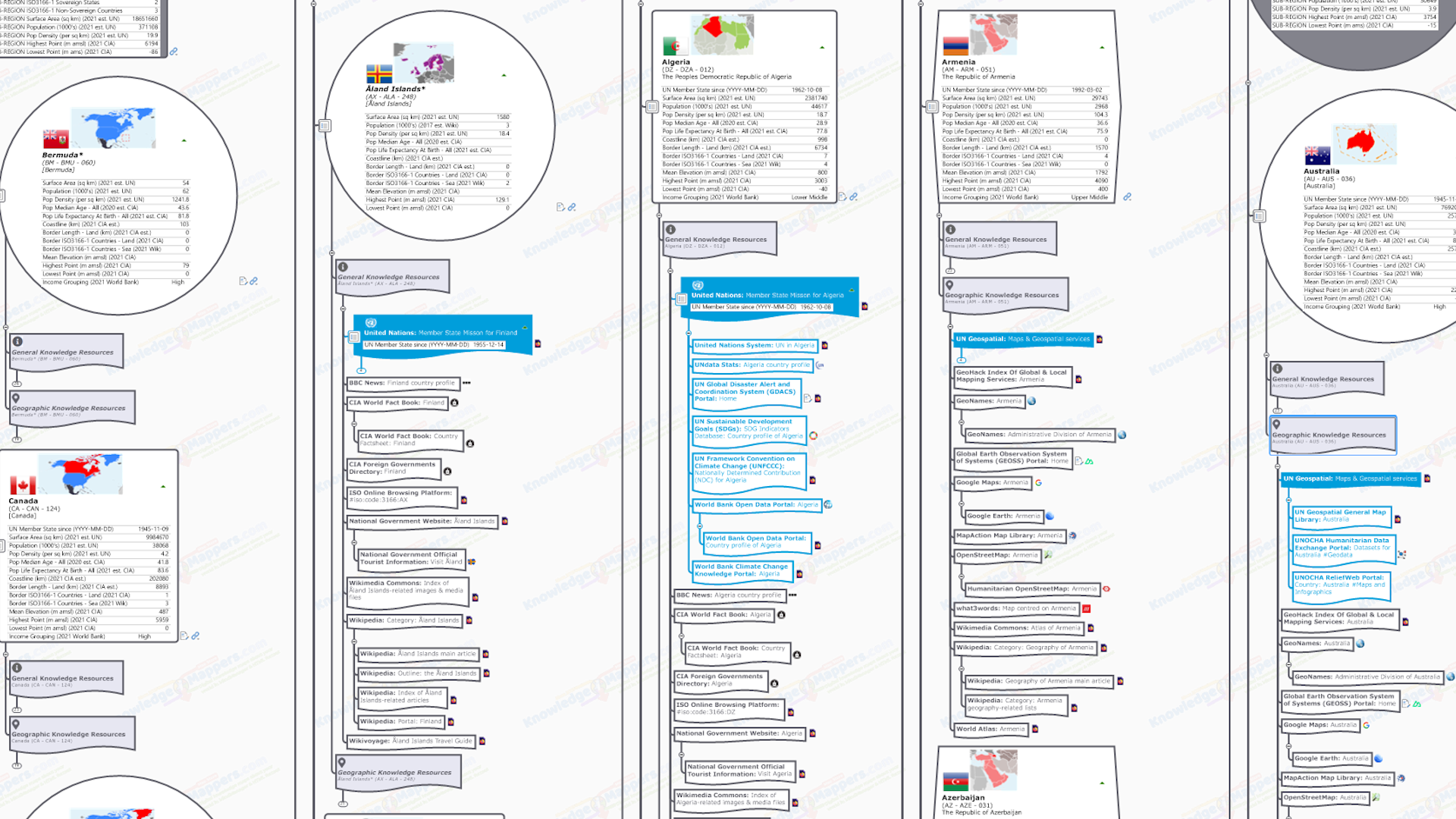
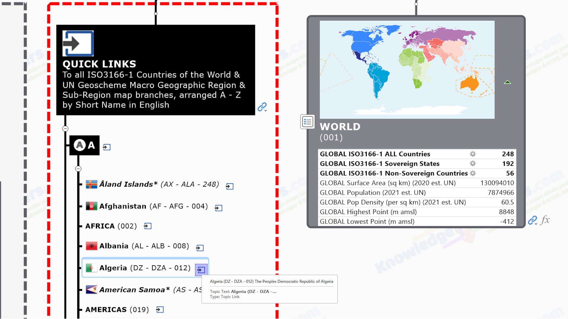
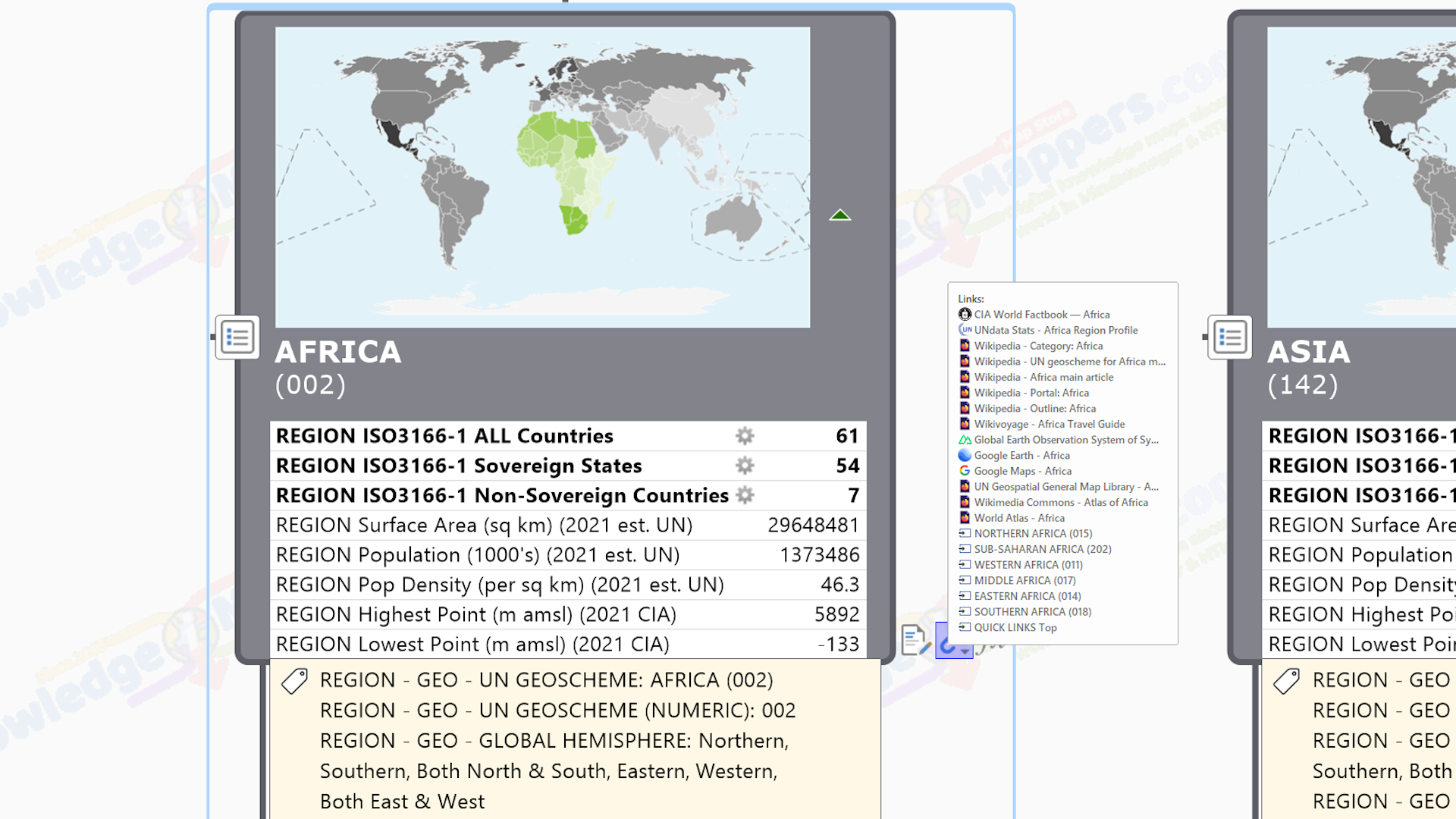
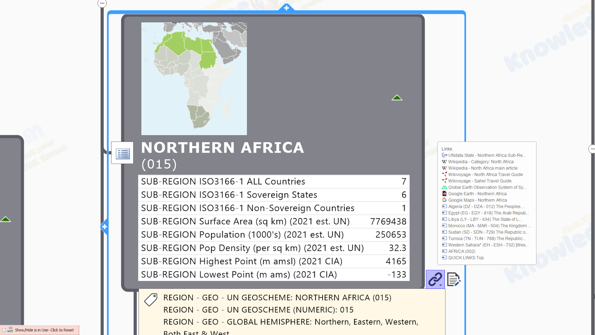
Groundbreaking Geographic & Knowledge Mapping Products & Services

Our maps visually connect individuals, teams, organisations & communities with what they need to know… so that they can to do what they need to do… quicker, easier and with a lot less stress!

Welcome To Knowledge Mappers

Knowledge Mappers is a unique, digital mapping consultancy & publishing company. Our ground-breaking knowledge products & services ‘visually connect’ people with what they need to know so that individuals, teams, organisations & communities can do what they need to do to move forward – quicker, easier and with a lot less stress 🙂

Geographic Mapping, Spatial Analysis & Data Portal Services

Our first passion is the mapping, analysis and sharing of geographic information (GI) – ie. the knowledge about the ‘places & spaces’ that make up our physical world and our interactions with them – and we have over 50 years of collective experience covering all aspects…

From it’s initial sourcing / capture, spatial analysis using GIS (from every day mapping tools like Google Maps and Google Earth, to full blown analysis software like ESRI, MapInfo and QGIS), and publishing & sharing with expert & non-expert stakeholders alike as both online map-enabled data portals and large format paper maps.

 Indeed our School Travel Health Check (STHC) spatial analysis service – which was born out of an initial GI consultancy project to provide high quality, spatial intelligence data to one local authority, it’s school communities and other stakeholders interested in how children travel to their school, from where, and how far they travel to get there – has been combining all of our GI skills in a nationally available, ‘one-stop shop’ service since 2005.

We are also passionate about the development of spatial data infrastructures (SDIs) at all levels to ensure that this key knowledge about their world is accessible to all who need it – be they members of the GI Professional Community or communities defined geographically – and they have the capacity to use it to support them in whatever it is they need to do, once they have it.

Note we are a registered data processor with the UK Information Commissioner (ICO).

Show more...

Knowledge Mapping & Corel (Mindjet) MindManager Services

Our other passion is combining that same unique range of data / information / knowledge hunting & cartographic expertise with Corel (formerly ‘Mindjet’) MindManager – the world’s best information (‘mind’) mapping software – to create multi-function knowledge maps (‘hierarchical tree diagrams’) that visually capture not only the various individual elements that make up just about any ‘knowledge space’ and the ‘spatial’ inter-relationships between them, but also the (potentially 1000’s of) official / definitive / plain old useful knowledge resources available about them in the public domain. So they are an interactive map, a visualy structured ‘discover within the bigger picture context’  index of online knowledge resources, and a ‘minimal-click’ portal to those resources all in one.

We began using MindManager to map the knowledge in our own ‘business space’ in 2002, but soon realised the technique could also be applied to mapping knowledge about the ‘real world geographic spaces’ with which we were familiar (or so we thought!), and then the everyday ‘time spaces’ that rule our lives. In fact we realised that we could use it to map – and bring clarity to – just about any ‘knowledge space’ that we humans have created to conceptually structure, physically manage and navigate our world on a day to day basis.

(Note you can see here an illustrated ‘walk through’ of the process of turning an official spreadsheet of information found in the online public domain into a visually structured knowledge map, taken from our ScotlandTheMap project).

Realising the value of these new ‘knowledge atlas’ and ‘knowledge calendar’ maps to everybody trying to build a better world (or at least their bit of it) – whilst simultaneously struggling with information overload and getting all the other stakeholders ‘on the same page’ – we decided to share them via our digital download map store, in both HTML5 and MindManager (.mmap) format. HTML versions (an export feature unique to MindManager) can be viewed by anybody using any modern browser, on any device, on or offline, without the need for any plugins, whilst anybody with access to MindManager software can use the original MindManager format maps as ‘ready made’ templates to amend, adapt & repurpose (in whole or in part) in their own projects so they do not have to re-invent the knowledge wheel each time. (MindManager is more usually famed for it’s rich feature set for project planning & execution.)

We also offer a bespoke knowledge mapping service for clients – especially for communities – as well as  consultancy & training. Along with our fellow partners in the MindManager International Value Added Partner (MIVAP) Network we also offer a complete MindManager consultancy service to help others to get the most value from this most amazing digital tool.

Show more...
Play Video

Our Products & Services

Browse our ground-breaking geographic and knowledge mapping products & services below. In our experience there are very few areas of human endeavor that don’t benefit from the increased understanding, buy-in and alignment amongst stakeholders that working visually brings. You are experts in what you do. Get in touch and let us help you do it better with what we do…

Clients, Testimonials & Citations

From the UK Chief Medical Officer to Local Council Officers, Project Managers and Headmasters, our mapping products and services have connected many individuals, teams, organisations & communities with the knowledge they need, to do what they need to do… quicker, easier, and with a lot less stress 🙂

UK Government Chief Medical Officer 2009 Annual Report

Our School Travel Health Check (STHC) Spatial Analysis Service is cited as the example of best practice for public health in the South West Region in the 2009 Annual Report of the UK Government Chief Medical Officer (see “Increasing active travel by schoolchildren” – p73).

“This innovative sustainable development initiative aims to provide robust data that will allow schools, planners and individuals to develop more sustainable school travel options.”

“Active travel to school is an important source of physical activity for young people. It could be increased further. These statistics provide a useful baseline against which to measure progress, and should be used in conjunction with a qualitative assessment of local authority and school travel policies.”

Why Knowledge Mappers?

Here are some of the reasons why our unique range of knowledge / information / data mapping skills & expertise can help you do what you need to do… quicker, easier and with a lot less stress…

0 +

Years Of Experience

We have decades of collective professional experience of all aspects of the sourcing, creation, analysis & sharing of information to provide meaningful insight to stakeholders.

Insight, Not Technology

Though technology is vitally important, it is just a tool, a means to an end. We never lose sight of the reason why we are using it, which is to provide you with meaningful insight into your world...

Standard Office Tools

We use the same standard technology tools as you - MS Office, MapInfo, QGIS, Google Maps, MindManager, Bootstrap, browsers... It's what we do with them that makes the difference!

Friendly & Approachable

We like to work in a collaborative way with our clients and partners so that we achieve more together. You are experts at what you do. We would like to help you do it better with what we do 🙂

Pragmatic Approach

We've been employees in the public sector and large corporations ourselves, so we know what it's like from both sides. That's why we offer things like 'flexible invoicing' to fit in with your budgetary cycle.

We Hate Waste

The wasting of your time hunting for the information you need. The waste of effort in creating knowledge resources that aren't as well used as they could be by those who would benefit from them most. We're doing our best to sort that!

MindManager Official Partners

As one of MindManager's International Value Added partners we feed in to the Beta development program and can draw from a huge pool of knowledge to help you get the most from the world's best information mapping software.

We're On The Supplier List

We are on several government supplier lists, including the Scottish & UK governments, as well as local authorities. Let us know if there's anything we can do to make procurement of our products & services any easier for you.

Community Benefit Focus

Community is what binds us together as a species. It is through community that probelms are identified, solutions arrived at & delivered, and success celebrated & shared. We especially enjoy working with communities (geographic or virtual) to help them move forward with what they want to do.

Knowledge Mappers News

Here’s the latest news from our blog….

Featured Resource

ISO 3166-1 Countries of the World Knowledge Atlas Maps

Play Video

Are you all sitting comfortably? Then we’ll begin…

Our Countries of the World – General & Geographic Atlas builds on the knowledge framework provided by our ISO3166-1 Countries Of The World – Base Atlas through the addition of collections of sub-branches off of the country seed branch, each with a single hyperlink to official / definitive / plain old useful General or Geographic knowledge resources about it found in the public domian…

General Knowledge Resource Link Collection – This includes the country’s page(s) for BBC News, CIA World Fact Book & World Leaders & Cabinet Members Directory, ISO Online Portal, Wikipedia Category & Main Article, Portal & Outline, and those produced by the United Nations Staistics Division.

Geographic Knowledge Resource Link Collection – This includes online mapping services like Google Maps and Open Street Map (with a summary of all available services on GeoHack), static map libraries from the United Nations Geospatial Division & agencies (eg. UNITAR) and WikiMedia Commons Atlas of the World, as well as the Wikipedia Geography Sub-Category & Main Article.

A selection of the most fundamental / useful of these general & geographic links (ie. not all) are the ones that have been attached to the country seed branches themselves to create – alongside those for the UN defined Macro Geographical (Continental) Regions And Sub-Regions – the ‘bigger picture’ visual framework that is the atlas basemap for all our ‘countries of the world’ knowledg maps.

This map is the ideal starting point for ‘thumb & brain friendly’ desktop (or even ‘in the field’) research for anyone with an interest in specific countries of the world.

MindManager Users – As with all our maps, the MindManager (.mmap) version of this map is also both a base map to add your own content to, or a source of content that can be added to your own existing maps.

Explore the other tabs for comprehensive descriptions of the knowledge seed branches and knowledge link collections that make up this knowledge atlas map….

View sample HTML5 map full screen

COMING SOON - View a sample of this HTML knowledge map as a stand-alone webpage in a new browser tab - it may take a few seconds to load, please be patient 🙂

Share

Please share this page with your networks and others you think will benefit from our visual working.

Digg
Facebook
LinkedIn
OK
Pocket
Pinterest
Reddit
Skype
StumbleUpon
Telegram
Twitter
Tumblr
VK
WhatsApp
XING
Email