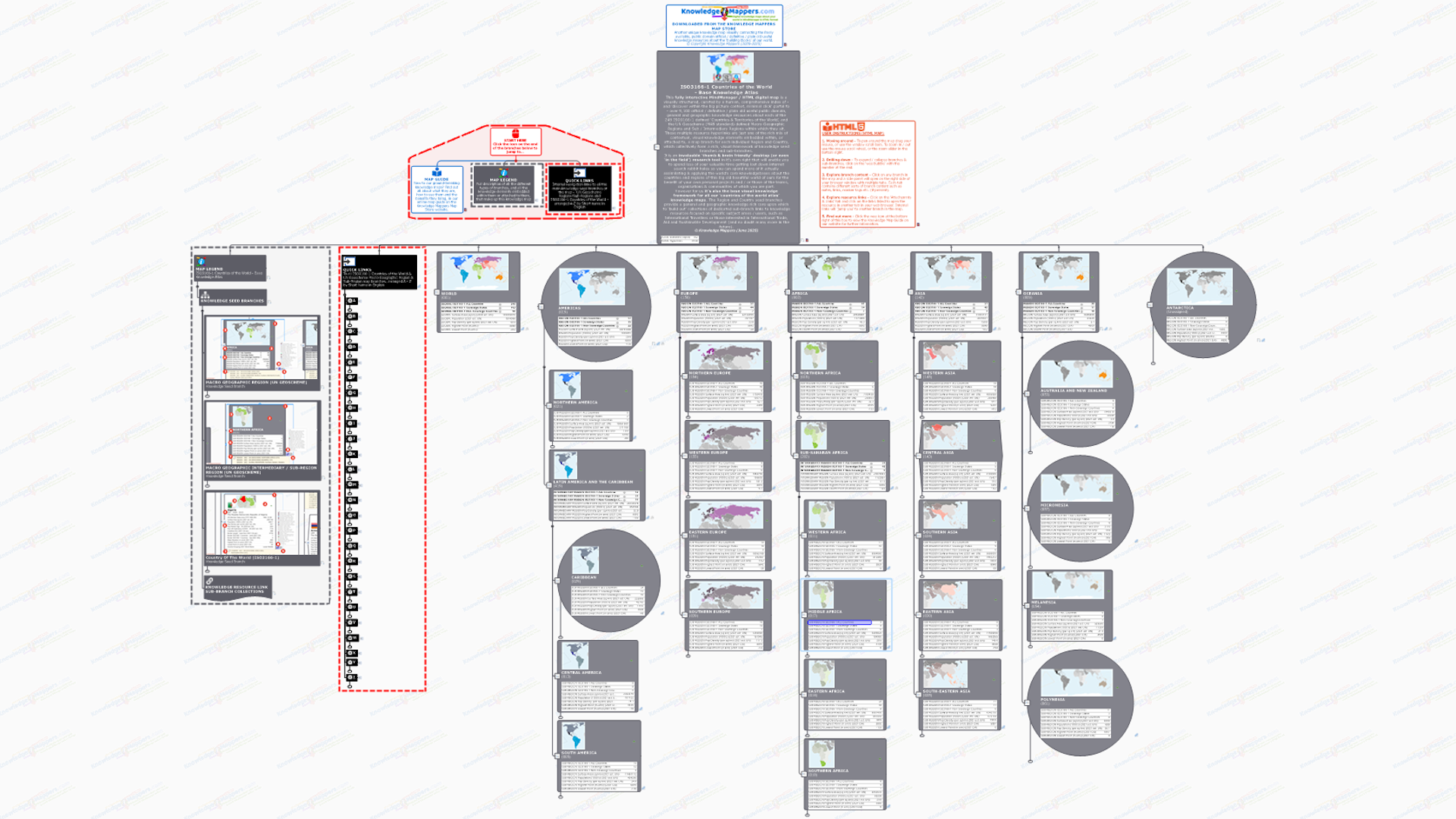
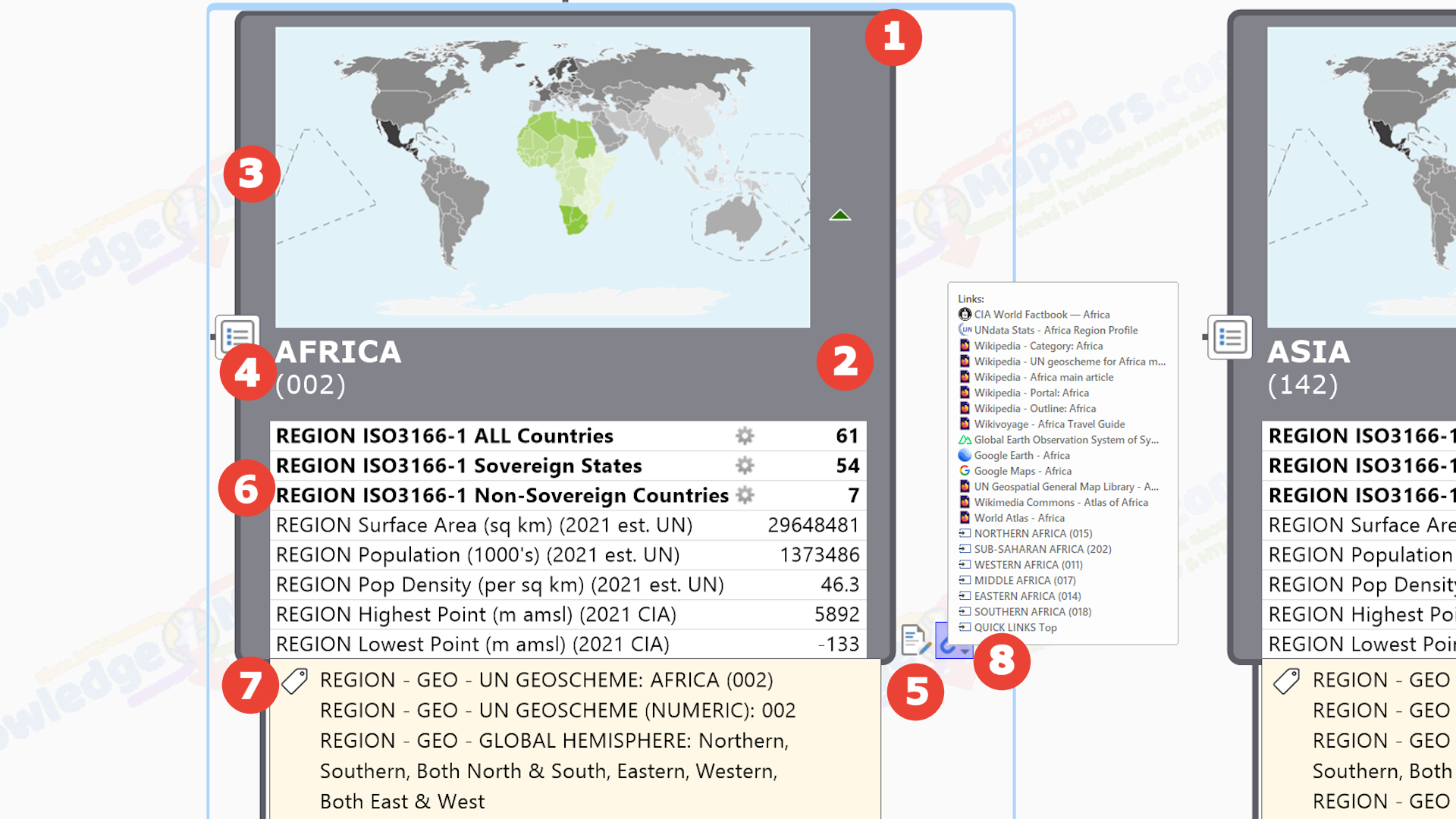
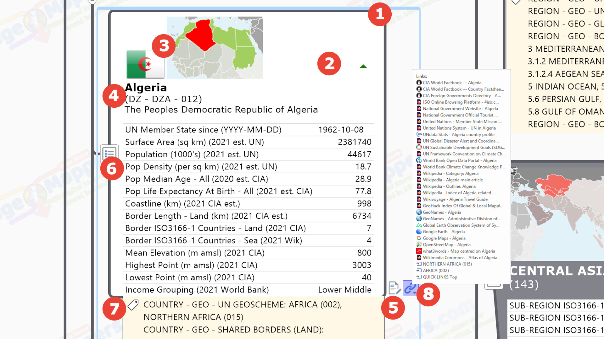
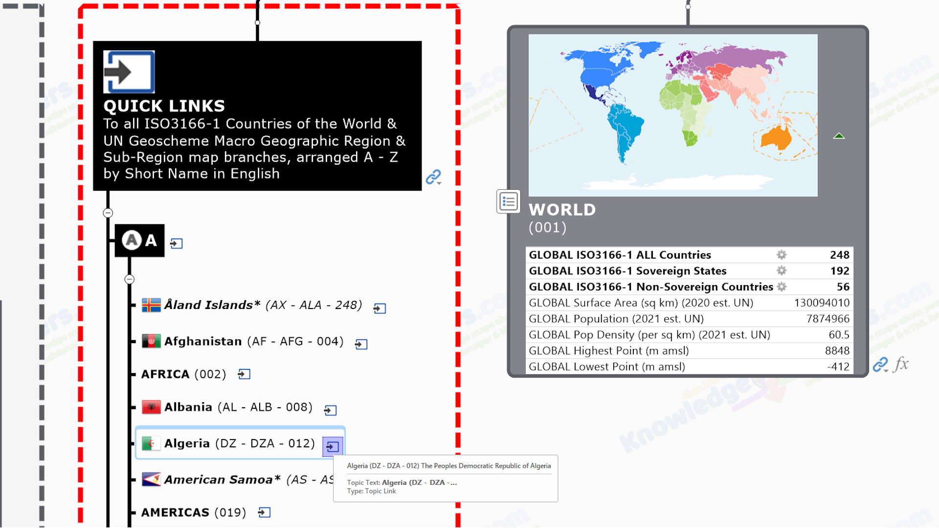
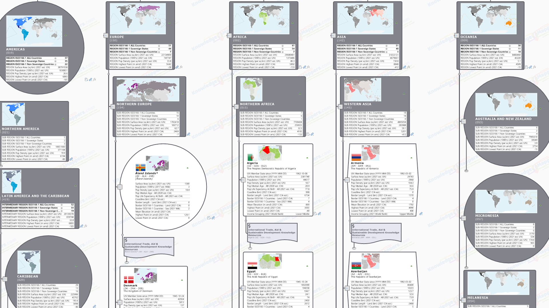
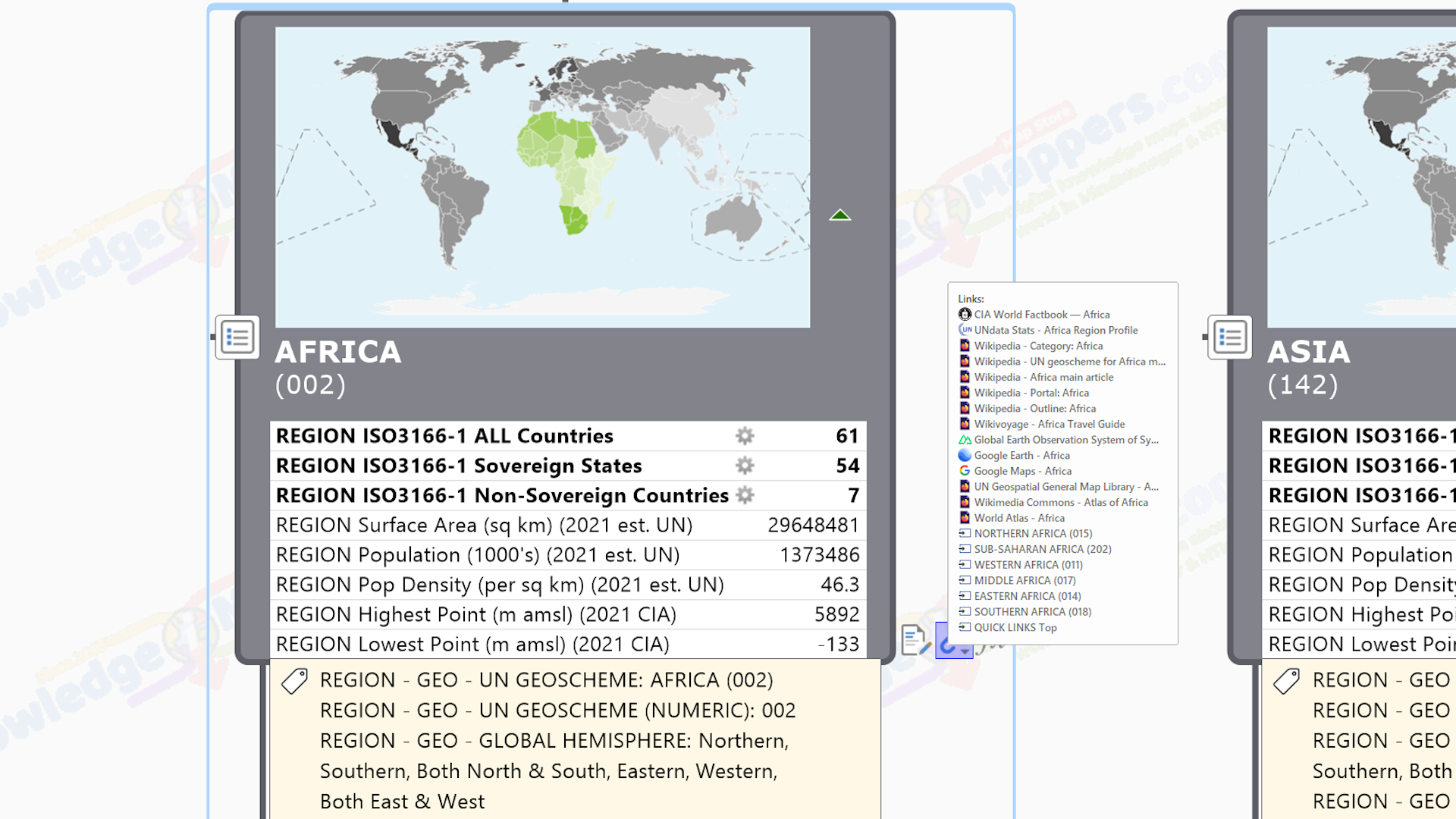
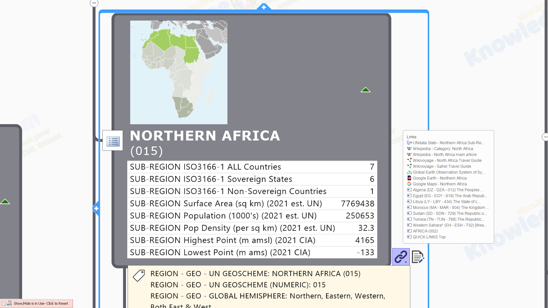
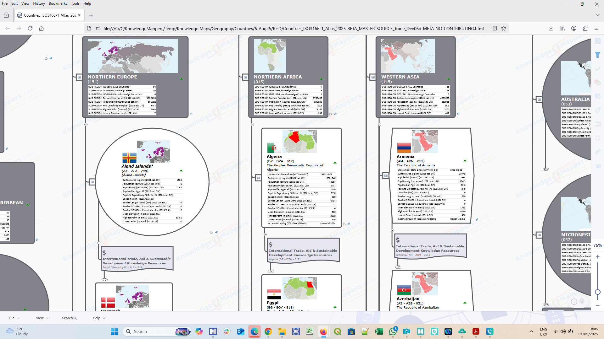
ISO3166-1 Countries Of The World

 United Nations System Resources
 European Union (EU) Resources
  Other Resources
 Wikimedia Project Resources
.
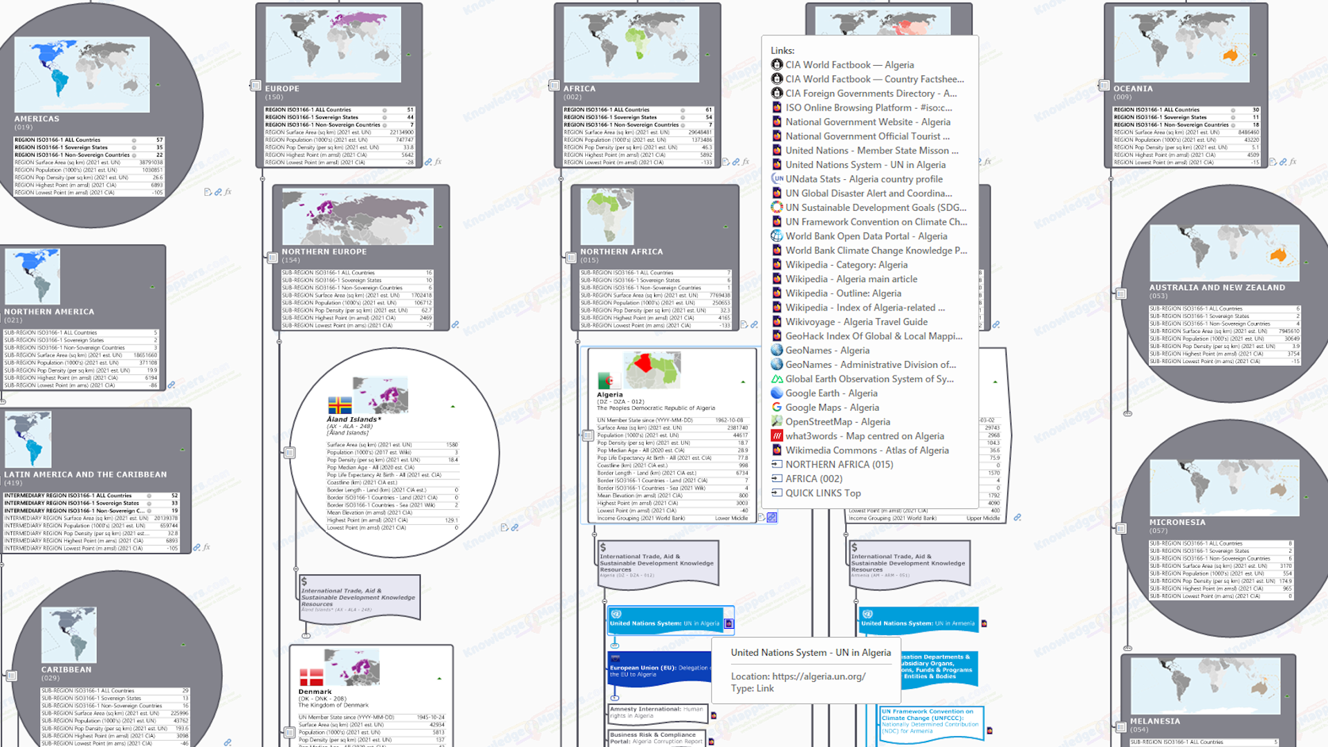
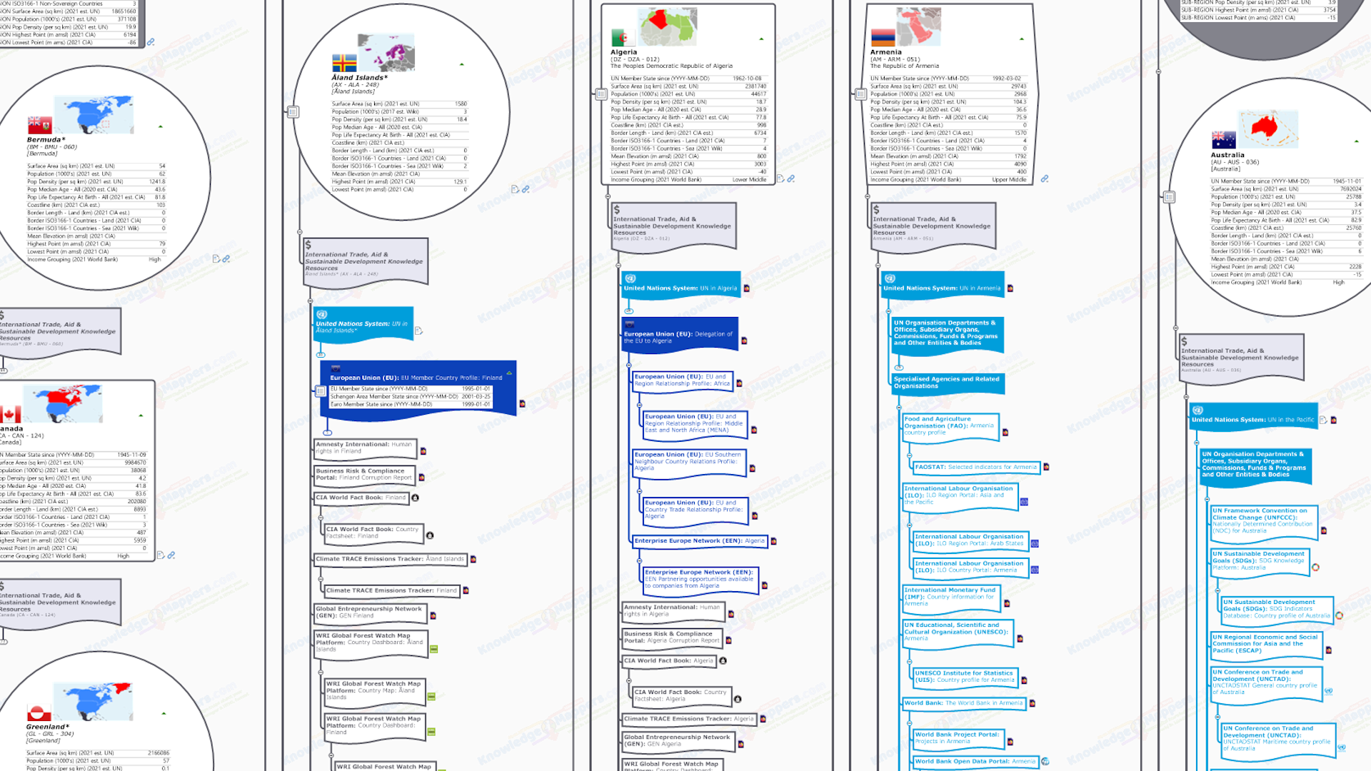
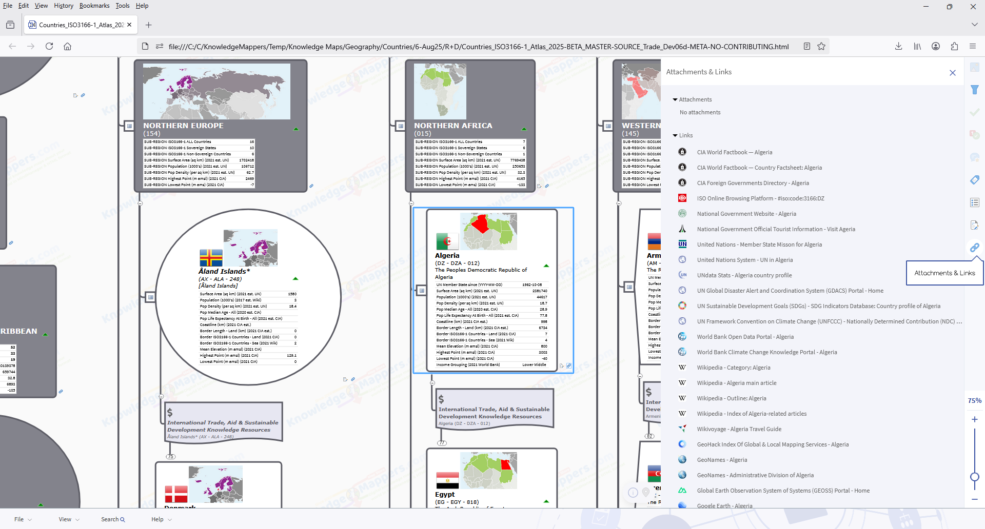
This collection contains links to official / definitive / ‘plain old useful’ knowledge resources around international trade, humanitarian aid and sustainable development involving the country. It is an ideal starting point for those who want to find out more about about it, be it for casual browsing or more focused desktop research for a specific purpose. The links are grouped together as follows….
United Nations System Resources
European Union (EU) Resources
Other Resources
Wikimedia Project Resources
This also coresponds to the order in which they are listed on the map itself….
.
United Nations System Resources
Unsurprisingly the many bodies that make up the United Nations System produce many knowledge resources about the international trade, humanitarian aid and sustainable development about the countries of the world. In fact so many that in the map we have split them into 2 sub-groups…
GROUP 1 – Entities classed as one of the following in the UN system organisation chart….
- Departments & Offices (of the Secretariat)
- Subsidiary Organs of the Main Bodies
- Commissions
- Funds & Programs
- Other Entities & Bodies
.
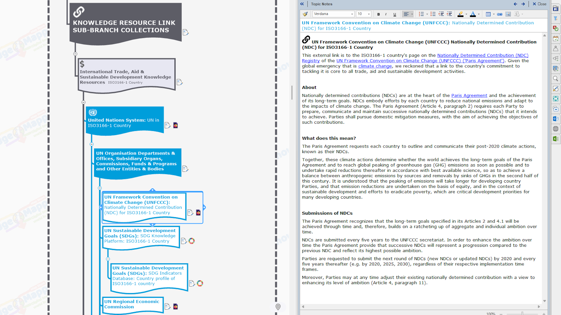
 United Nations Framework Convention on Climate Change (UNFCCC): Nationally Determined Contributions (NDC) Registry – The country’s total carbon contributions as agreed under the United Nations Framework Convention on Climate Change (UNFCCC) (‘Paris Agreement’).
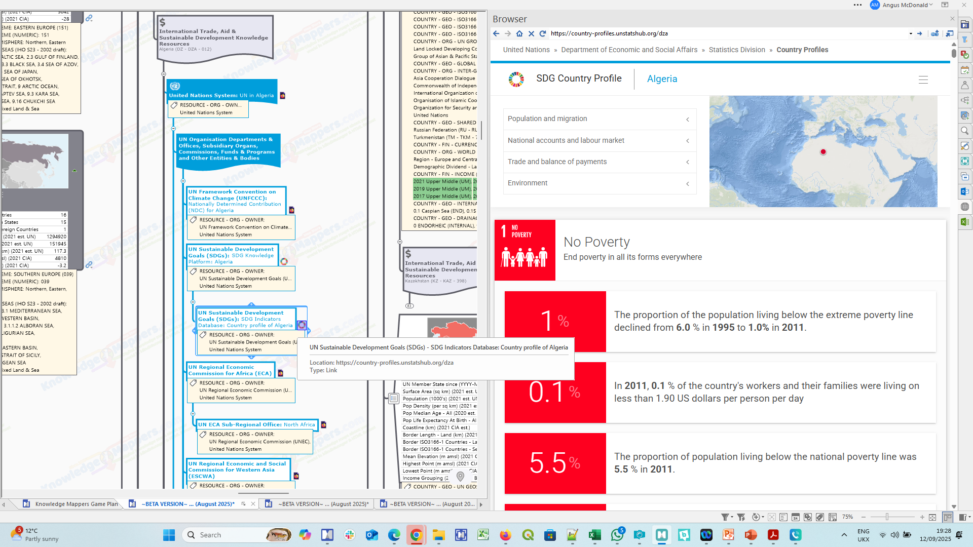
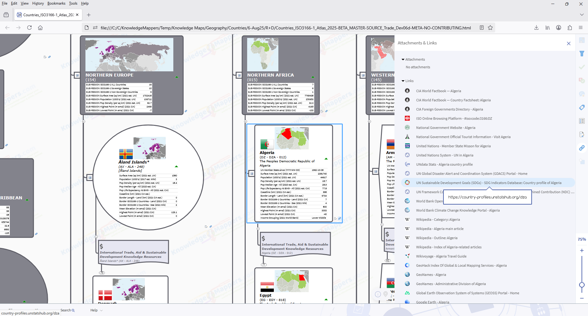
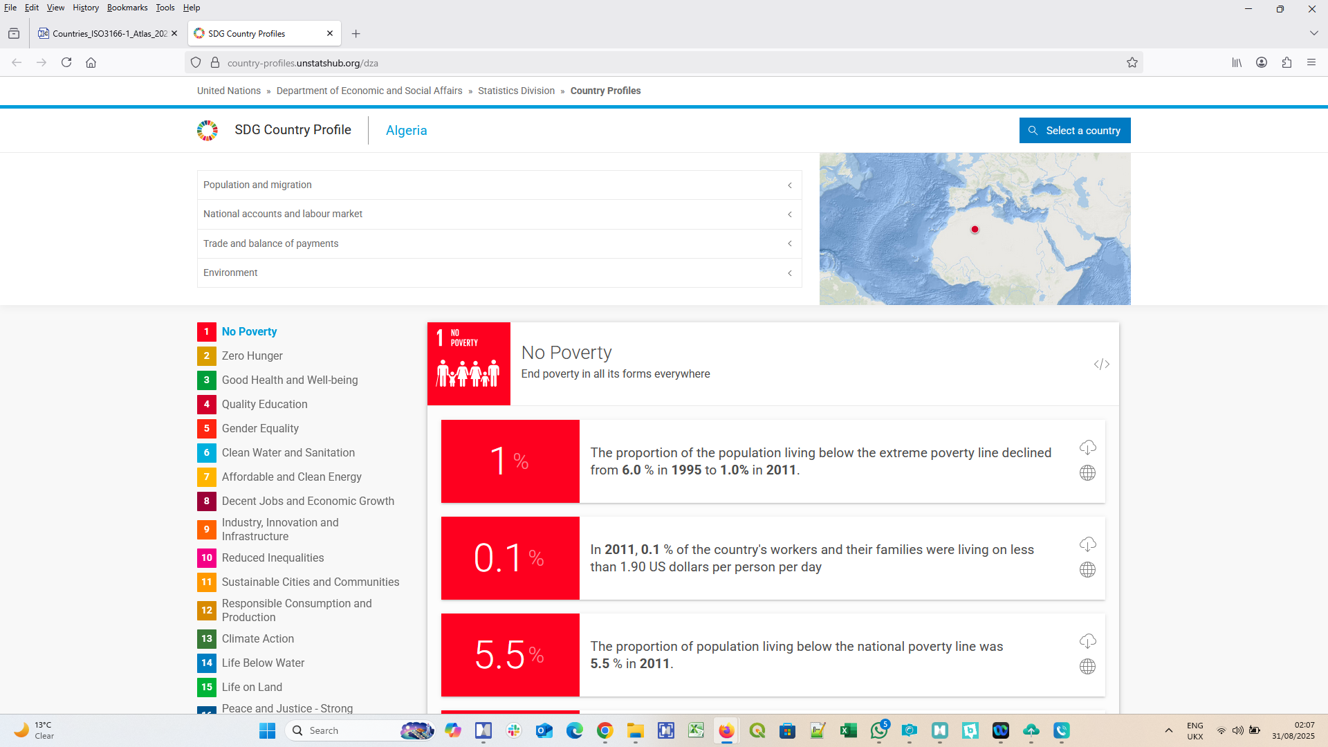
UN Sustainable Development Goal (SDG) Knowledge Platform – Country – The ISO3166-1 country’s profile page on the UN Sustainable Development Knowledge Platform, which is maintained by the Division for Sustainable Development Goals (DSDG) in the United Nations Department of Economic and Social Affairs (UNDESA) as pat of it’s remit to provide wide access to information and knowledge for sustainable development to Member States, Major Groups and other stakeholders, as well as the general public.
Note(s)
i) Site migration and updated URL’s – As of December 2022 the SDG Knowledge Platform has been ‘mostly’ migrated from the https://sustainabledevelopment.un.org/ url to https://sdgs.un.org/, with the website at the ‘old’ url being “no longer maintained or updated”. However the links to the pages for the member states in the new website link back to those in the old website, so it would seem that the migration process is not yet complete. Thus until it is, we will keep our links as they are.
UN Sustainable Development Goal (SDG) Indicators Database Country Profile – The SDG Global Database provides access to data on more than 210 SDG indicators for countries (Member States), areas or regions across the globe.
UN Regional Economic Commission – The relevant regional Economic Commission covering the ISO3166-1 country, which is one 5 established by the Economic and Social Council (ECOSOC) of the United Nations…
The mandate of each commission is to…
- promote the economic and social development of the member states in the region.
- foster intra-regional integration.
- promote international cooperation for the sustainable development of the region.
.
UN Conference on Trade and Development (UNCTAD) Data Hub (UNCTADSTAT) – Country Profiles – The ISO3166-1 country’s general profile page on the United Nations Trade and Development (UNCTAD) Data Hub, which provides a basic snapshot of a country’s economic and financial situation, facilitating convenient cross-country comparisons. There are links to 2 profiles….
- General – basic snapshot of the country’s economic and financial situation.
- Maritime – basic snapshot of a country’s situation on maritime transport and international trade.
.
UN Development Program (UNDP) Regional Bureau for ISO3166-1 Country – The UN Development Program (UNDP) works in about 170 countries and territories, helping develop policies, leadership skills, partnering abilities, & institutional capabilities to achieve the eradication of poverty, and the reduction of inequalities & exclusion, as well as the resilience to sustain the development results. The UNDP Regional bureaus covering each ISO3166-1 country corespond to the Regional Commissions…
.
UN Development Program (UNDP) ISO3166-1 Country Office – The website dedicated to the work of the UNDP in one of 170 ISO3166-1 countries and territories, the URL of which is a subdomain of the main UNDP website i.e. countryname.undp.org.
Note(s)
i) UNDP location-based websites – The UNDP gas created websites for it’s work in different localtions around the world, the URL of which is a subdomain of the main UNDP website i.e. countryISO3166-1alpha2code/regionname.undp.org. However there is no web page listing them. Instead all can be accessed by clicking on the globe icon in the top corner of the menu bar on any of the UNDP websites.
ii) ‘Developed Countries’ – Most ‘developed nations’ will not have a dedicated UNDP website. However in the map there will at least be a branch for the regional UNDP that covers it, as well as their entry in the transparency portal as a donor country.
UN Development Program (UNDP) Transparency Portal ISO3166-1 Country Profile -This external link is to the ISO3166-1 country profile page on the UNDP Transparency Portal, which contains detailed information on the UNDP’s 5,000+ development projects in some 170 countries and territories worldwide. The portal enables users to find project information categorized broadly by location, funding source, and focus areas, and drill down for comprehensive project data, including budget, expenditure, completion status, implementing organization, contribution to gender equality, project documents, and more. Open.undp.org features current project site images and is integrated with UNDP country office external web sites to enhance knowledge sharing.
UN High Commissioner for Refugees (UNHCR) Regional Bureau – The UN High Commissioner for Refugees (UNHCR) is a global organization dedicated to saving lives, protecting rights to seek asylum and find safe refuge, and building a better future for refugees, forcibly displaced communities and stateless people who have fled violence, persecution, war or disaster at home. The UNHCR Regional Bureau help coordinate ongoing work and initiatives with the country offices dealing with refugees fleeing emergency situations….
Note(s)
i) UNHCR location-based websites – The UNHCR has created websites for it’s work in different localtions around the world, all can be accessed by clicking on the globe icon in the top corner of the menu bar on any of the sites.
ii) 2 websites for each region – There are 2 websites for each geographic region…
iii) Sub-regions – There are also a couple of other sub-regional websites only accessible from the Change Site menu…
.
UN High Commissioner for Refugees (UNHCR) Country Office – The ISO3166-1 country offices of the UN High Commissioner for Refugees (UNHCR) undertake ongoing work and initiatives on the ground dealing with refugees fleeing emergency situations.
Notes(s)
i) 2 websites for each country – There are 2 ‘country websites’ for each country…
- a page on the main UNHCR global site, accessed from the ‘About UNHCR > Where We Work page, or from the region page on the main UNHCR website e.g. Rwanda (unhcr.org/countries/rwanda), from which the other country-based pages can be accessed…
- Help site – Contains information about your rights as a refugee or asylum-seeker in the country e.g. Help Rwanda.
- Country Office – Contains more information on the work of UNHCR in the country and the latest local news and stories Rwanda (unhcr.org/rw).
- Global Focus (Operational updates) – UNHCR’s reporting portal containing up-to-date information about UNHCR programmes and operations in the country, including funding level and donor contributions e.g. Global Focus Rwanda.
- the country office site as above, accessed from the country page on the main website via a drop-down list, or from ‘Change site’ menu in the top menu bar of any of the websites e.g. Rwanda (unhcr.org/rw).
.
United Nations Children’s Fund (UNICEF) Regional Office – UNICEF, the United Nations agency for children, works to protect the rights of every child, especially the most disadvantaged and those hardest to reach, across more than 190 countries & territories, doing whatever it takes to help children survive, thrive and fulfil their potential – providing and advocating for education, health & nutrition services, protect them from violence and abuse, bringing clean water and sanitation to families in need, and keeping them safe from climate change and disease. The UNICEF Regional Bureau help coordinate ongoing work and initiatives with the country offices….
.
United Nations Children’s Fund (UNICEF) ISO3166-1 Country Office / National Committee – The UNICEF Country office do whatever it takes to help children survive, thrive and fulfil their potential. There are sections on relevant background information about the country and it’s national UNICEF Ambassadors, country-specific research and reports and how you can help locally.
In ‘developed nations’ there isn’t a country office but there may be a UNICEF’s National Committee, which works locally to promote children’s rights, raise funds to support UNICEF’s work and provide visibility to children’s issues worldwide.
UNICEF Data and Analytics Portal ISO3166-1 Country Profile – The UNICEF Data and Aanalytics Portal features the latest available country-level data, with over 60 indicators pertaining to the wellbeing of women and children, reported in the following groups …
- Child health
- Child protection
- Child survival
- Early childhood
- Education
- HIV/AIDS
- Maternal and newborn health
- Nutrition
- Sanitation
- Drinking water
.
United Nations Office for the Coordination of Humanitarian Affairs (UNOCHA) Regional / Country Offices – The United Nations Office for the Coordination of Humanitarian Affairs (OCHA) contributes to principled and effective humanitarian response through coordination, advocacy, policy, information management and humanitarian financing tools and services. OCHA’s country and regional offices are responsible for delivering the core functions in the field by leveraging functional expertise throughout the organization….
Note(s)
i) Europe – There is no formal Regional Office for Europe, however OCHA does have a presence on the ground as its European headquarters are located in Geneva, Switzerland and OCHA’s Centre for Humanitarian Data is located in The Hague, the Netherlands.
UN Global Disaster Alert and Coordination System (GDACS) Portal – Real-time access to official web-based disaster information systems and related coordination tools for recent (last 5 days) earthquakes, tropical cyclones, floods, volcanic eruptions, droughts and forest fires.
UNOCHA Humanitarian Data Exchange Portal: Geodata Datasets for ISO3166-1 Country – The ISO3166-1 country’s page on the Humanitarian Data Exchange (HDX) portal – which is a humanitarian information service provided by the United Nations Office for the Coordination of Humanitarian Affairs (OCHA) – containing the latest available country-level, downloadable datasets for use by all the humanitarian actors responding to emergency situations.
Note(s)
i) Getting started – New users are directed to the Getting Started section of the FAQ page.
UNOCHA Reliefweb Portal: ISO3166-1 Country Page – The ISO3166-1 country’s page on the ReliefWeb portal – which is a humanitarian information service provided by the United Nations Office for the Coordination of Humanitarian Affairs (OCHA) – containing shared, curated content that is most relevant to global humanitarian workers and decision-makers on a 24/7 basis, enabling them to make informed decisions and to plan effective response.
UNOCHA ReliefWeb Response Portal for ISO3166-1 Country – The ISO3166-1 country’s page on the ReliefWeb Response portal – which is a humanitarian information service provided by the United Nations Office for the Coordination of Humanitarian Affairs (OCHA) – containing aggregated content from multiple platforms to provide an authoritative source for information in new and existing humanitarian operations to facilitate situational understanding and decision-making, including situation reports, dashboards, maps and infographics.
Note(s)
i) Getting started – New users are diretcted to the Help page.
United Nations Peacekeeping Mission to the ISO3166-1 country – UN Peacekeeping helps countries navigate the difficult path from conflict to peace by deploying troops and police from around the world, integrating them with civilian peacekeepers to address a range of mandates set by the UN Security Council and General Assembly. There are currently 11 UN Peacekeeping Missions in operation around the world, and the link (if present) is to latest facts about them on the UN Peacekeepng website.
World Food Programme (WFP): ISO3166-1 Country Profile – The World Food Programme (WFP) is the leading humanitarian organization saving lives and changing lives, delivering food assistance in emergencies and working with communities to improve nutrition and build resilience. As the international community has committed to end hunger, achieve food security and improved nutrition by 2030, one in nine people worldwide still do not have enough to eat. Food and food-related assistance lie at the heart of the struggle to break the cycle of hunger and poverty. On any given day, WFP has 5,600 trucks, 30 ships and nearly 100 planes on the move, delivering food and other assistance to those in most need in 88 countries.
World Food Programme (WFP) Food Security Analysis Platform (VAM): ISO3166-1 Country – The ISO3166-1 country’s page on the VAM Platform – the eyes and ears of the World Food Programme (WFP) – which provides credible, relevant, and timely food security analyses and evidence that forms the basis for the design of the WFP’s strategic and operational decision-making, resource mobilization and accountability. The platform seeks to answer some critical questions…
- Who is food insecure or vulnerable?
- Why are they food insecure or vulnerable?
- How many are they?
- Where do they live?
- What should be done to save their lives and livelihoods?
- How is the situation likely to evolve and what are the risks threatening them?
- How effective and efficient is WFP’s response?
.
WFP World Hunger Map LIVE – This global hunger monitoring platform combines key metrics from various data sources – such as food security information, weather, population size, conflict, hazards, nutrition information and macro-economic data – to help assess, monitor and predict the magnitude and severity of hunger in near real-time. The resulting analysis is displayed on an interactive world map that helps WFP staff, key decision makers and the broader humanitarian community to make more informed and timely decisions relating to food security. The platform covers 94 countries, including countries where WFP has operations as well as most lower and lower-middle income countries (as classified by the World Bank).
Note(s)
i) No link to individual country views – Although the platform has live views for those 94 countries – accessed from the drop down list in the top left of the screen – the site architecture is such that they can’t be linked to as they don’t have distinct URLs (indeed none of the menu options alters the URL in the browser bar). Thus users will have to manually select the country view they want.
.
GROUP 2 – Entities classed as one of the following in the UN system organisation chart….
.
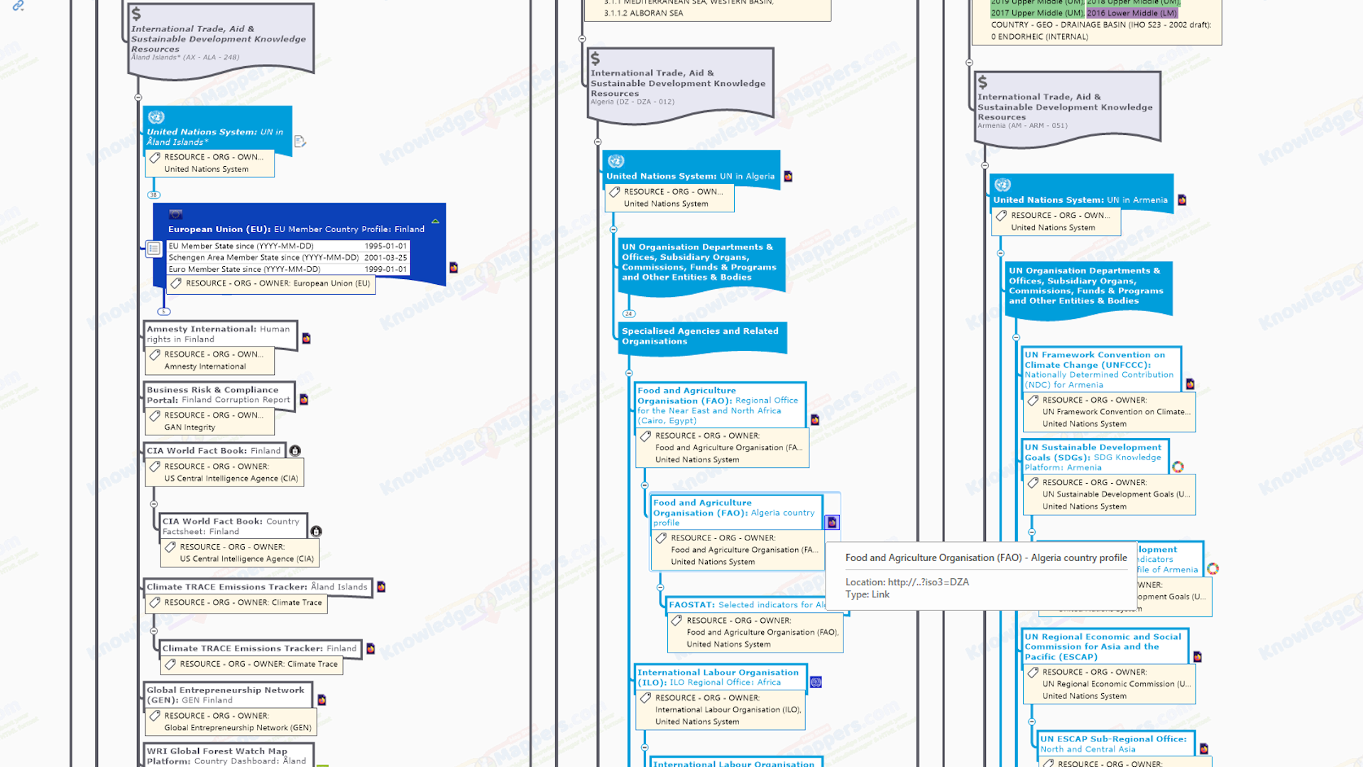
Food and Agriculture Organisation (FAO) Regional & Country Offices – The Food and Agriculture Organization (FAO) is a specialized agency of the United Nations that leads international efforts to defeat hunger. Working in over 130 countries worldwide, it’s goal is to achieve food security for all and make sure that people have regular access to enough high-quality food to lead active, healthy lives. The FAO Regional Bureau help coordinate ongoing work and initiatives with the country offices….
Each region also operates sub-regional offices.
Food and Agriculture Organisation (FAO) Country Office – The main work of FAO Country offices is to assist national governments in developing policies, programmes and projects to address the root causes of hunger and malnutrition; help them develop their agricultural, fisheries and forestry sectors, and also use their environmental and natural resources in a sustainable way.
Food and Agriculture Organisation (FAO) FAOSTAT Data Platform Selected Inidicators for ISO3166-1 Country – The FAOSTAT platform provides free access to food and agriculture data for over 245 countries and territories and covers all FAO regional groupings from 1961 to the most recent year available. The country’s page contains a location map and data charts under the following headings…
- Demographics
- Inputs
- Hunger and food insecurity
- Food availability
- Food access
- Food utilization
- Land
- Production
- Emissions
Note(s)
i) All data listed – The full range of datasets incorporated into the platform is listed here.
International Labour Organisation (ILO) Regional Portal – The International Labour Organization (ILO) is devoted to promoting social justice and internationally recognized human and labour rights, pursuing its founding mission that social justice is essential to universal and lasting peace. The only tripartite United Nations agency, since 1919 the ILO brings together governments, employers and workers of 187 member States, to set labour standards, develop policies and devise programmes promoting decent work for all women and men. The Regional / Sub-Regional offices (and coresponding portal) help coordinate ongoing work and initiatives with the country offices to promote rights at work, encourage decent employment opportunities, enhance social protection and strengthen dialogue on work-related issues together with worker, employer, and government partners….
.
International Labour Organisation (ILO) Country Office – ILO ‘Country Offices’ usually cover more than one country, and have a separate web page to the individual Country Portals.
International Labour Organisation (ILO) Country Knowledge Portal – The ILO knowledge portal connects country information and data on labour laws, standards, policies and statistics as well as providing relevant information on ILO projects and programmes, publications and good practices.
International Monetary Fund (IMF) ISO3166-1 Country Profile – The International Monetary Fund (IMF) is an international organization of 191 countries, working to foster global monetary cooperation, secure financial stability, facilitate international trade, promote high employment and sustainable economic growth, and reduce poverty around the world. The ISO3166-1 country profile page contains links to country specifc news, data, documents and links.
Note
i) Covers Non-Sovereign Territories too – On the country pages the term ‘country’ does not in all cases refer to a territorial entity that is a state as understood by international law and practice. As used here, the term also covers some territorial entities that are not states. Dependent territories of member countries are listed alphabetically followed by a description of the constitutional relationships with their member countries.
United Nations Educational, Scientific and Cultural Organization (UNESCO) Member State Profile – UNESCO, the United Nations Educational, Scientific and Cultural Organization, is a specialized agency dedicated to strengthening our shared humanity through the promotion of education, science, culture, and communication. It sets standards, creates tools, and advances knowledge to tackle global challenges, promoting equality and peace. Its work includes protecting biodiversity, addressing AI, improving education, safeguarding heritage, and ensuring reliable information. The ISO3166-1 country’s member state page lists the Ratified and Non-ratified Conventions it is part of….
- Intangible Cultural Heritage
- Man and the Biosphere
- World Heritage List
- Learning Cities
- Memory of the World
….and the lists of & data about the things in the country scheduled by them.
UNESCO Institute for Statistics (UIS) Country profile for ISO3166-1 Country – The UNESCO Institute for Statistics (UIS) data platform has country level data that fuels the national policies and investments needed to transform lives and propel the world towards its development goals. It is grouped under the headings of…
- Education and Literacy
- Science, Technology and Innovation
- Culture
.
United Nations Educational, Scientific and Cultural Organization (UNESCO) Regional / National Field Office – UNESCO has a network of field offices that undertake it’s work on the ground with local partners. Offices may cover one country (termed a ‘National Office’), or several (termed a ‘Regional Office’), though not all member states (especially ‘developed nations’) are listed as having a designated field office. If there is one, it will be linked to in the country portal.
World Bank: The World Bank In ISO3166-1 Country – The World Bank Group works in more than 170 countries, working with partners in the public and private sectors in their efforts to end poverty and tackle some of the most pressing development challenges.
World Bank Project Portal: Projects in ISO3166-1 Country – Since 1947, the World Bank has funded over 12,000 development projects around the world in over 177 countries, via traditional loans, interest-free credits, and grants.
World Bank Open Data Portal – Free and open access to the global development data about countries or development indicators held by the World Bank. Graph, map and compare more than 1,000 time series indicators from the World Development Indicators by Topic, Theme and SDG Goal.
World Bank Open Data Portal: ISO3166-1 Country – This site is designed to make World Bank data easy to find, download, and use. All of the data found here can be used free of charge with minimal restrictions.
World Bank Open Data Country Profile – Country’s data profile page on the World Bank Open Data Portal (only accessed from the country’s data page). It is similar in style to the country profile page on the UNdata platform apart from the fact that as well as the latest year, there is data for every 10 years going back to 1990. Data about the country is from the World Development Indicators database, and is grouped under the categories of World View, People, Environment, Economy & Global links.
World Bank Climate Change Knowledge Portal: ISO3166-1 Country – In an effort to serve as a ‘one stop shop’ for climate-related information, data, and tools, the World Bank created the Climate Change Knowledge Portal (or CCKP). The Portal provides an online tool for access to comprehensive global, regional, and country data related to historical and future climate, vulnerabilities, and impacts as well as deeper analysis insights into climate risks and adaptation actions.
World Health Organisation (WHO) Regional Office – Public health overview of the larger region of which the country is part.
World Health Organisation (WHO) Country Overview – Public health overview of the country as a member state of the WHO on the WHO Global website.
World Health Organisation (WHO) Regional Country Overview – Public health overview of the country as a member state of the WHO region on the regional website (if available).
World Health Organisation (WHO) Global Health Observatory Country Profile – WHO’s gateway to public health-related statistics for each Member State, with over 1000 indicators on priority health topics as tables, graphs and charts.
World Meteorological Organisation (WMO) – Regions – The 6 WMO Regional Assocaitions coordinate meteorological, hydrological, climatological and related activities of their Member States, as part of the WMO’s global responsibility for monitoring the state and behaviour of the Earth’s atmosphere, its interaction with the land and oceans, the weather and climate it produces and the resulting distribution of water resources.
World Meteorological Organisation (WMO): Member State – The Member State page on the main World Meteorological Organisation (WMO) website contains links to the WMO Community Platform, WMO Experts Database, the Country’s 7 day forecast page on the World Weather Information Service (WWIS) website and the Region activity page for the WMO Region of which the member state is part.
World Trade Organisation: Member / Accession Information for ISO3166-1 Country – The World Trade Organization (WTO) is the only global international organization dealing with the rules of trade between nations. At its heart are the WTO agreements, negotiated and signed by the bulk of the world’s trading nations and ratified in their parliaments. The goal is to help producers of goods and services, exporters, and importers conduct their business.
WTO Trade Agreements Database: Country – The ISO3166-1 country’s entry on the WTO’s Regional Trade Agreements (RTAs) Database, which is a repository of the legal texts and annexes of all RTAs notified to the WTO, preferential tariff and trade data provided by RTA parties, and other related documents. The platform covers RTAs for which an early announcement has been made as well as those currently in force.
.
European Union (EU) Resources
As one of the largest economic unions of ‘developed nations’ in the world, it is not surprising that the various bodies of the EU system produce knowledge resources about the international trade, humanitarian aid and sustainable development about the countries of the world. However which branches are included under the link collection for a country will depend on whether it’s a member or not (or maybe an aspiring member)….
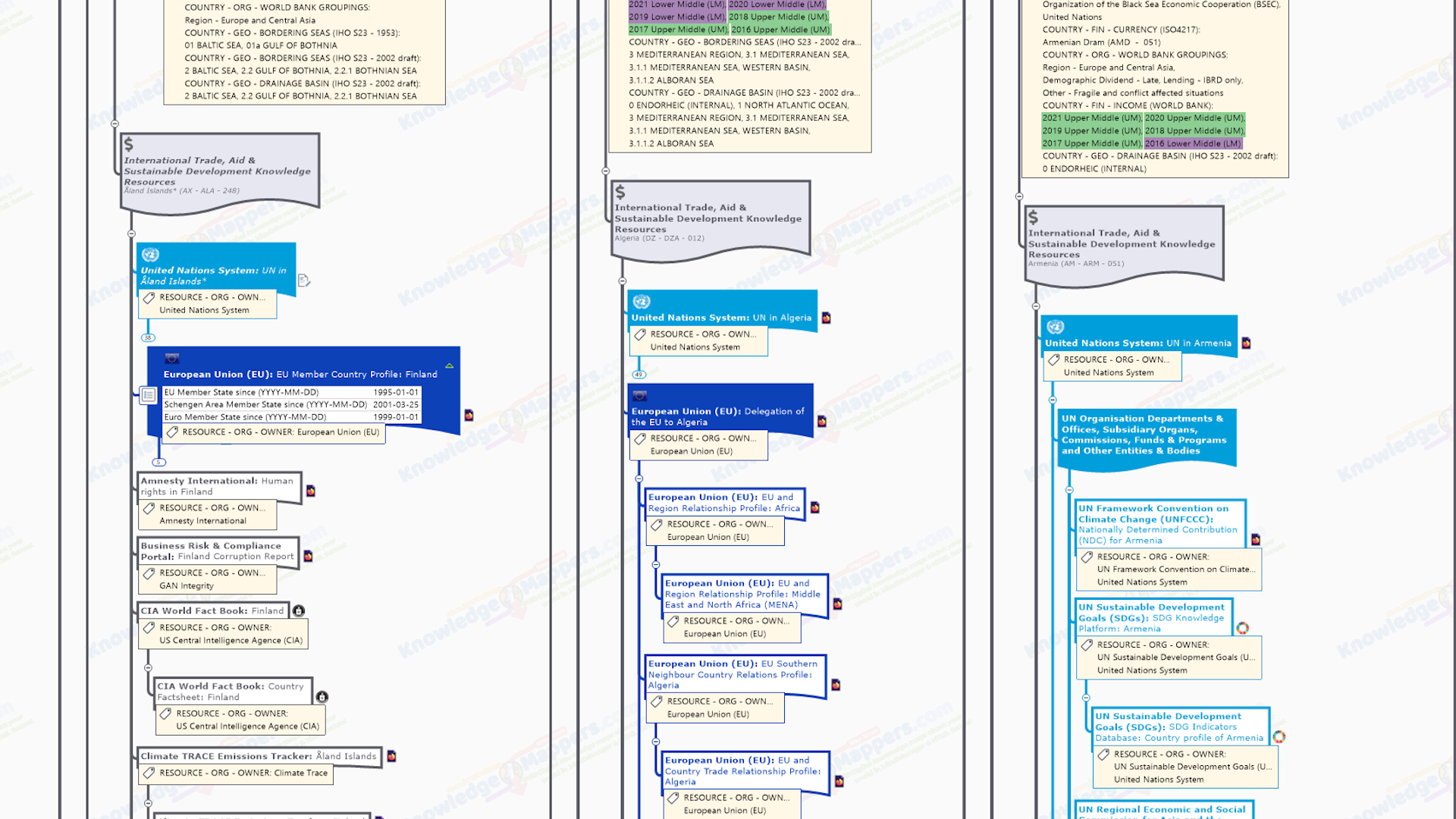
European Union EU Member Country Profile – The EU member state’s ‘official country profile page’ on the Europa EU overview website summarises it’s political system, trade and economy, participation as a Member State in the various EU bodies, budgets and funding and how it benefits from being a member (eg EU funded projects). In addition the branch for EU Member State includes the following embedded Single Data Fields….
 EU Member State since (YYYY-MM-DD) – Shows the date on which the country joined the EU.
Schengen Area Member State since (YYYY-MM-DD) – Shows the date on which the country joined the EU Shengenn Area. Schengen is the world’s largest area of freedom, security and justice without internal frontiers. It guarantees free movement to more than 450 million EU citizens, along with non-EU nationals living in the EU or visiting the EU as tourists, exchange students or for business purposes (anyone legally present in the EU).
Euro Area Member State since (YYYY-MM-DD) – Shows the date on which the country joined the EU Euro Zone. The euro is the most tangible proof of European integration: around 341 million people use it every day, making it the second most-used currency worldwide. The benefits of the common currency are immediately obvious to anyone travelling abroad or shopping online on websites based in another EU country. Currently, the euro (€) is the official currency of 20 out of 27 EU member countries which together constitute the Eurozone, officially called the euro area.
This branch serves as an anchor branch for the sub-collection of other EU Member State related links branches.
European Union Delegation to the ISO3166-1 Country – The website of the EU Delegation to the ISO3166-1 country. Run by the European External Action Service (EEAS) of the European Union, there is a standard website layout for all countries, with lots of information about the bilateral relationship between them and the EU. In particular there is a summary of political, economic & trade relations, technical, financial & cultural cooperation and humanitarian aid.
As there is a website on the EU’s permanent mission to (or at least a page on the relations with) every other non-EU ISO3166-1 country in the world (sovereign states anyway), this branch serves as an anchor branch for the sub-collection of other EU-Country related links branches.
Note(s)
i) Regional and other Country information –The EEEAS website also has sections on it’s general work and relations with different Macro-Geographic Regions as well as specific regional policy areas such as the European Neighbourhood Policy, which in turn may contain country-specific information.
European Union EU Regional Policy ISO3166-1 Country Relations Profile – There is an EU-non-EU ISO3166-1 country relations profile page for different areas of EU regional policy on the European External Action Service (EEAS) of the European Union website (click on ‘EU in the World’). For example the European Neighbourhood Policy (ENP) covers neighbouring countries to the east, and the whole Mediterranean basin (including North Africa).
If the country is in the Accession Process to join the EU, the country profile page branch will include the following embedded Single Data Field…
EU Candidate State since (YYYY) – Shows the year in which the country was accepted as a Candidate State to begin the process of joining the EU (according to the Potential enlargement of the EU > Candidate Countries section of the EU Enlargement page on the Europa EU overview website).
European Union and Country / Region Trade Relationship Profile – The EU-ISO3166-1 Country Trade Relationship profile page on the Trade and Economic Security section of the European Commission website. contains a range of useful information about the country / region’s trade with the EU.
Note(s)
i) Regional Trade Blocs –There are also trade profiles for macro-geographic regions (though they do not necessarily corespond to the UN Geoscheme ones) and some named regional trade blocs.
ii) Trade statistics by trading partner – Overview and detailed view statistics for each region / country are available as downloadable PDF files from the Statistics page (arranged A-Z by Partner).
European Union EU-Region Relations Profile – The EU-Macro Geographic Region relations profile page on the European External Action Service (EEAS) of the European Union website. Note the regions do not necessarily corespond to the UN Geoscheme ones, and are defined more by areas of Regional Policy. There are profile pages for the following Regions…
Note(s)
i) Regional Policy profiles –The EEEAS website also has sections on EU regional policy, such as The European Neighbourhood Policy (ENP) which covers neighbouring countries to the east, and the whole Mediterranean basin (including North Africa). which in turn may contain country-specific information.
Enterprise Europe Network (EEN) Local Contact Points & Partnering Opportunities for ISO3166-1 Country – The Enterprise Europe Network (EEN) is the world’s largest support network for small and medium-sized enterprises (SMEs) with international ambitions to help them innovate and grow on an international scale. The worldwide network brings together experts from local member organisations – chambers of commerce and industry, regional development organisations, universities and research institutes & innovation agencies – that know the local business environment but also have expertise and contacts for business opportunities worldwide. There are 2 country-level pages we link to…
Note(s)
i) Global coveage – At time of writing there are populated ‘EEN Local Contact Point’ pages’ for all 27 EU member states and a similar number of other non-EU ISO3166-1 countries from around the world. However there are actuall pages for all other ISO3166-1 counties which (presumably) will become populated over time, and so we have included the links to them in the map. ‘EEN Partnering Opportunities’ are open to all countries, although by definition there are more opportunities available to EU member countries.
Association of European (EU) Chambers of Commerce (Eurochambres) Members – Established in 1958 as a direct response to the creation of the European Economic Community (now European Union), Eurochambres represents more than 20 million businesses – over 93% of which are SMEs – through its members and a network of 1,700 regional and local chambers across Europe. It is the leading voice for the broad business community at EU level, building on chambers’ strong connections with the grass roots economy and their hands-on support to entrepreneurs. The members page on the Eurochambres website lists the national chambers of commerce in 3 categories…
- Full members – Those for EU member states
- Affiliated Members – Those for 4 countries of the European Free Trade Association (EFTA) and the 9 EU Candidate Countries.
- Correspondent Members – A few others.
.
Other Resources
Resources that aren’t created by United Nations System bodies or Wikimedia projects….
Amnesty International – Range of news and reports about the human rights situation in the country.
Business Anti Corruption Portal: ISO3166-1 Country Corruption Report – A free resource produced by GAN Integrity (a provider of all-in-one compliance software to help companies of all sizes manage regulatory and legal compliance), the Business Anti Corruption Portal provides a comprehensive overview of the corruption risk of over 125 countries around the globe. The reports are broken down by categories ranging from the judicial system to civil society.
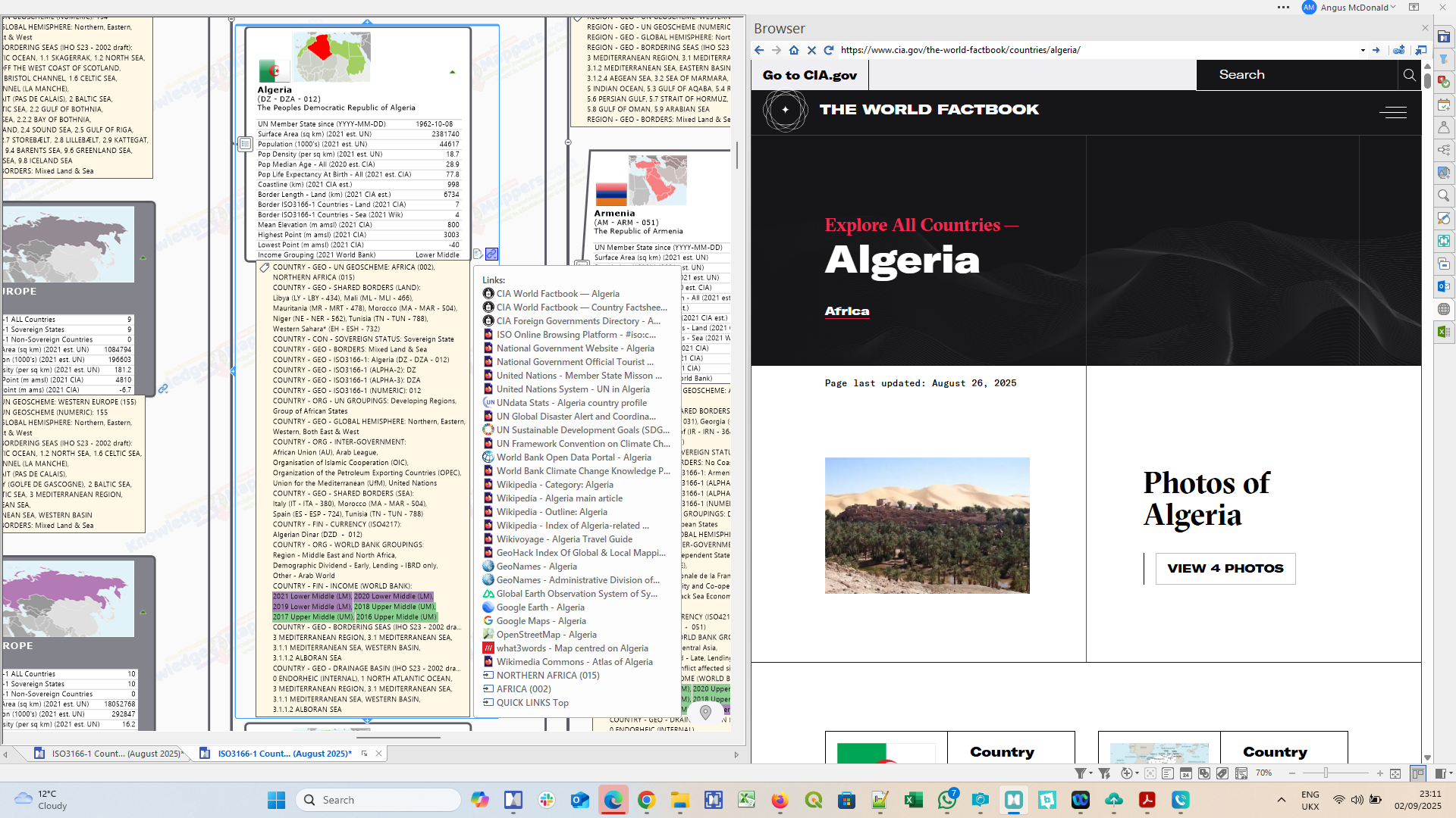
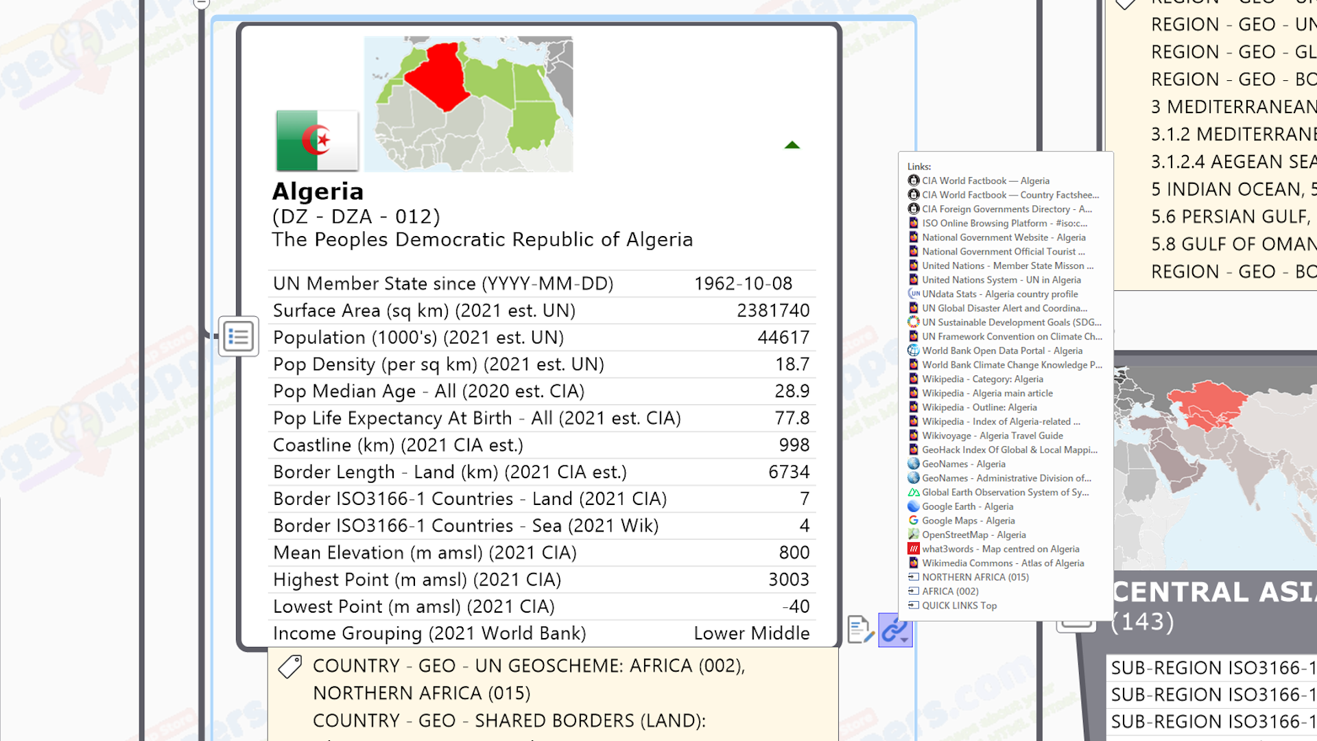
CIA World Fact Book: ISO3166-1 Country Profiles – Maintained regularly by the US Central Intelligence Agency, the World Fact Book contains information on the history, people, government, economy, energy, geography, communications, transportation, military, and transnational issues for 267 world entities. The Reference tab includes: maps of the major world regions, as well as Flags of the World, a Physical Map of the World, a Political Map of the World, a World Oceans map, and a Standard Time Zones of the World map.
CIA World Fact Book: ISO3166-1 Country Factsheet – ‘One page’ summary of key geostatistical facts and graphics about the country distilled from it’s entry in the main CIA World Fact Book under the categories of Geography, People & Society, Government and Economy.
Climate Action Tracker (CAT) ISO3166-1 Country Report – The Climate Action Tracker (CAT) tracks government climate action commitments and measures it against the globally agreed Paris Agreement aim of “holding warming well below 2°C, and pursuing efforts to limit warming to 1.5°C.” Countries are given an overall rating from ‘Critically Insufficient’, through ‘Highly Insufficient’, Insufficient’, ‘Almost Sufficient’ to ‘1.5 degrees Paris Agreement Compatible’ (spoiler alert: none of them are the latter :-(, as well as for the individual areas of…
- Policies and Action
- Conditional Nationally Determined Contribution (NDC) target
- Unconditional Nationally Determined Contribution (NDC) target
- Climate Finance
- Net zero Target
This resource puts the country’s UN Framework Convention on Climate Change (UNFCCC) Nationally Determined Contribution (NDC) (also linked to in this knowledge map) into context.
Note(s)
i) Global coverage – CAT tracks 34 countries and the EU, which includes all the biggest emitters and a representative sample of smaller emitters covering about 85% of global emissions and approximately 70% of global population.
Climate Trace Emmissions Tracker ISO3166-1 Country – The Climate Trace Emmission Tracker tracks total greenhouse gas (GHG) emissions – CO2, CH4, N20 and total CO2 equivelant (i.e. total of all GHGs) – based on direct, independent observation using satellite imagery and other forms of remote sensing, artificial intelligence, and collective data science expertise to track human-caused GHG emissions as they happen from individual sources. In addition to the individual country GHG inventory broken down by sector, there is a comparison tool to view 2 countries side-by-side, and a global map. The innovative, open, and accessible approach uses advances in technology to fill critical knowledge gaps for all countries that otherwise rely on the patchwork system of self-reporting that serves as the basis for most existing emissions inventories.
Global Entrepreneurship Network (GEN) ISO3166-1 Country – The Global Entrepreneurship Network (GEN) operates programs in 200 countries aimed at making it easier for anyone, anywhere to start and scale a business. By fostering deeper cross-border collaboration and initiatives between entrepreneurs, investors, researchers, policymakers and entrepreneurial support organizations, GEN fuels healthier start and scale ecosystems that create more jobs, provide education, accelerate innovation, and strengthen economic growth. The ISO3166-1 country’s page contains information on the work of the ‘local chapter’ in helping local entrepreneurs realise their ideas and how to get involved.
WRI Global Forest Watch Map For ISO3166-1 Country – Established by the World Resources Institute (WRI) in 1997 as part of the Forest Fronteirs Initiative, Global Forest Watch (GFW) is an online platform that provides data and tools for monitoring forests via interactive charts and maps that summarize key statistics about the country’s forests. Statistics and global rankings – including rates of forest change, forest extent and drivers of deforestation – can be customized, easily shared and downloaded for offline use. By harnessing cutting-edge technology, GFW allows anyone to access near real-time information about where and how forests are changing around the world….
- Dashboard View – The dashboards help answer important questions about forest change in any area and enable you to view hundreds of statistics through interactive charts and graphs, all derived from analysis of spatial data. Statistics can be customized to be as general or specific as you like and can be easily shared and downloaded for offline use.
- Map View – The map view helps tell a visual story about what’s happening to forests in a particular place. Zoom in anywhere in the world to explore how forests are changing, how they’re managed and the values they provide. Layer data – like annual tree cover loss, land use data and satellite imagery – to better understand the underlying causes and impacts of forest change. You can embed a map view on another website, share via social media or email, or take a screenshot to use in a report.
Note(s)
i) Getting the most out of it – As this is a very data rich resource with a lot of options, users are advised to look at the Help Centre, especially the step-by-step instructions.
Human Rights Watch – Range of news and reports about the human rights situation in the country.
International Chamber of Commerce (ICC) ICC World Chamber Network – Through a unique mix of advocacy, solutions and standard setting, the International Chamber of Commerce (ICC) champions the needs of businesses, large and small, in global decision-making and leveraging private sector know-how to deliver solutions that turn interconnected challenges into opportunity for all, making it easier for businesses to trade internationally. The World Chambers Federation (WCF) Network Directory section of the ICC website lists the WCF members and affiliates from over 124 countries and territories, from all regions of the world in a table and on a world map.
Note(s)
i) Using the table -The table lists the member chambers – national, regional or other – alphabetically by chamber name by default, however it can be re-ordered to display them alphabetically by country or macro geographic region.
International Chamber of Commerce (ICC) ICC National Committees Network – ICC National Committees advise the country’s companies in their daily work and represent the country’s international economic community within the ICC globally. The contact details for the national committee for each country is listed in the ICC National Committees section of the ICC website. In outr map there is a link to this list page and to the committee itself (if they have a website).
Note(s)
i) Accessing the list – The list (half way down the page) is accessed via a world map in which either clicking the country list on the left side, or the dot over the country on the map, will pop up the details, which includes address and telephone numbers. However not all committees have a website listed, which is why we have included this page so that at least users can see if there is a central point of contact for a country of interest.
ii) Not all countries have a national committee – In countries where a national committee has yet to be formed, companies, banks, law firms, chambers of commerce, individuals, associations, and other organisations can join ICC by becoming a direct member. Please contact the ICC Global Headquarters in Paris for information on becoming a direct member.
Organisation for Economic Co-operation and Development (OECD) ISO3166-1 Country – The Organisation for Economic Co-operation and Development (OECD) is an international organisation that works to shape better policies that foster prosperity, equality, opportunity and well-being for all through establishing evidence-based international standards together with governments, policy makers and citizens. This link is to the ISO3166-1 country’s ‘page’ on the OECD website. however the contents of the page will depend on if the country is one of the 38 current OECD members (of which 20 are original founder members from 1960) or not…
- Non-member Country’s page – This is just the ‘published resources’ content page – Datasets, Reports, Working papers, Case studies, Country notes, Policy papers – filtered for the country.
- Link to the country’s current ‘Ambassador to the OECD’ page, which in turn links to the ‘Country’s Permanent Mission to the OECD’ page (created and externally hosted by the country’s government).
- Related publications for the country (with a ‘See all publications’ link to the same page as for the non-member countries).
- ‘Key indicator’ data charts for the country.
- Insights into the country.
 In addition, the branch for OECD member countries includes an embedded Single Data Field showing the date on which the country either joined, or when formal discussions with the country about becoming a member of the OECD began.
Note(s)
i) Country joining / accessing date – The member country’s page (or the page on member countries) does not contain information on the date when it actually fully became an OECD member. That information has come from this Wikipedia article (another example of where the official site does not (no longer? never did?) contain historical information that would still be considered ‘useful’!).
.
Wikimedia Project Resources
Wikipedia has many portals, outlines, categories, main articles & lists that are general knowledge resources about the countries of the world, however there are also other Wikimedia Projects of interest….
Wikipedia: ISO3166-1 Country Outline Page – Outlines are an introduction to the ISO3166-1 country structured as a series of hierarchical lists of links to essential Wikipedia resources about it.
Wikipedia: ISO3166-1 Country Main Article – This is the main Wikipedia article summarising the etymology, history, geography, administrative divisions, politics, economy, demographics & culture of the country. It also serves as a jumping off point to the many, more detailed Wikipedia articles on the country, as well as external sources on the web.
Wikipedia Category: Economy of ISO3166-1 Country – Contains all sub-categories and pages about the economy of the country. A good ‘jumping off point’ for further armchair / desktop exploration…
Wikipedia: Economy of ISO3166-1 Country Page – The main article about the geography of the country…
Wikipedia Category: Education in ISO3166-1 Country – Contains all sub-categories and pages about health in the country. A good ‘jumping off point’ for further armchair / desktop exploration.
Wikipedia: Education in ISO3166-1 Country Main Article – The main article about health in the country.
Wikipedia Category: Health in ISO3166-1 Country – Contains all sub-categories and pages about health in the country. A good ‘jumping off point’ for further armchair / desktop exploration.
Wikipedia: Health in ISO3166-1 Country Main Article – The main article about health in the country.
.
General Note(s)
i) Freely available – All knowledge resources linked to in our collections are freely available in the public domain.
ii) Not always available – Not all of the knowledge resources listed above exist for all ISO3166-1 countries. This is especially true for non-sovereign states, which may be fully autonomous or semi autonomous from the home state, or may be a fully integrated part of it. At the very least though there should be a WikiVoyage entry.
iii) Use in conjunction with General & Geographic Knowledge Resources – Specialised resource collections like this should be used in conjunction with those in the General & Geographic link collections, some (~30) of which are attached to the ISO3166-1 Country seed branch. The full range of links in these collections are to be found in the latest Countries of the World – General & Geographic Knowledge Atlas.
iv) Tagged with producing organisation – All knowledge resource link collection sub-branches are tagged with the ‘RESOURCE – Owner’ index marker tag, which identifies the organisation that produces it.

